Friday, June 29, 2018

06/23/18-6/24/18 - Moon Rocks

Saturday morning, we left for Arco, Idaho and Craters of the Moon National Monument and Preserve.  It was an easy drive up I-15 up from SLC.  We then turned onto US-20 W into Arco.  I-15 out of SLC runs along the foot of the Wasatch Range and along the east side of the Great Salt Lake.  Unlike say I-95 or I-64, there is some scenic value on interstates out west.

Arco, ID represents the furthest west we will travel on this trip.  After leaving Arco, we will, slowly at first, begin heading east.

Following are some pictures of the ride to the northwest.

The Wasatch Range is on our right as we leave SLC and Utah.


Yours truly, with the Great Salt Lake on my far left.

Idaho at last.


For a moment, I thought I'd entered a time warp, and was being transported back to
Virginia.

Irrigated spud fields.  You didn't think you weren't going to see a Russet potato field in Idaho, did you?

While there are mountains around, we're in the high plains now.

The rest of the pictures were taken in the Craters of the Moon National Monument and Preserve.  Again, like Capital Reef, a lot of rocks will be seen, but unlike Capitol Reef, these will be volcanic in origin.

I apologize for the blue tint many of the pictures have, including the ones taken while we traveled.  I accidently changed the White Light to Tungsten instead of sunlight on the Cannon .

This picture is for artistic purposes only.

Pool of lava.


This is one form of lava flow.  The Hawaiian name is 'a 'a.  Note the rough hard cinder stones that are pushed along.  The Illustration picture was taken in Hawaii.


This is the other major type of lava flow.  In Hawaiian, it's pronounced "pa hoe hoe".  Again the illustration is from Hawaii.  It's a smooth flow, and what most people think of due the pictures in the news currently coming from Hawaii.

Vegetation will grow anywhere.  This is one of the processes that, over the millenia, will eventually reduce lava fields to real dirt.

Another gratuitous artistic picture, at least to me.  I generally like pictures of single dead trees.

More beauty growing amongst the black volcanic rock.

Tree clinging to life.

The following pictures are from the Devil's Orchard.  A minister, years ago, visited and said it was an orchard fit for the devil.


Flowers even in the Devil's Orchard.

I told you I do like dead single trees.

Mary in the Devil's Orchard.

Devil's Orchard.

Explanation of past mismanagement due to good intentions.

This is an example of such mismanagement.


An explanation of and picture of a cinder garden.

The next set of pictures is of the Inferno Cone Overlook.  And yes, Mary and I climbed this hill too.


Inferno Cone Overlook.


This is the same shot, except the first is with a 300 mm zoom lens, and the second is with a 55 mm lens.

Looking down the overlook.

Mary headed down the overlook.

Looking up towards the top.  Yes, I have done some walking/climbing so far on the "vacation".

Yours truly nearing the bottom.


Splatter cones explained.

Trail out to the splatter cones.

One of the two splatter cones we will visit.


Not Joe, but Erroll vs the Volcano, ; )

Another splatter cone.

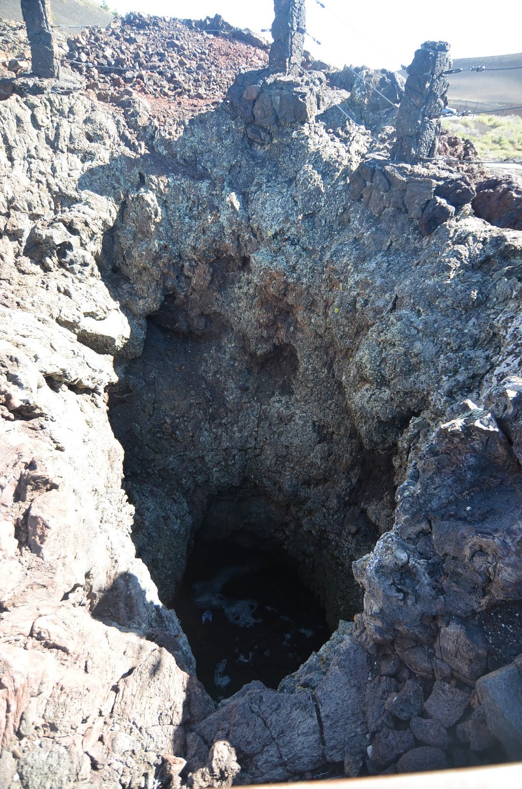
 Looking into the mouth.

Lichen growing on the inside wall of the splatter cone.


The former picture was taken in Hawaii.  It shows how a lava cave is formed.  The bottom picture is of an example at Craters.  This one is called Dew Drop Cave.


Beauty grows in desolation.

This finishes our visit to Craters of the Moon.  While this park is probably not on anyone's bucket list, I think it's a unique place, and both interesting and beautiful, in it's own stark, desolite way.  Tomorrow we're off to the Tetons, and a distinctly different form of beauty.

Later.


Thursday, June 28, 2018

Friday-06/22/18 - The Capital and the Antelope

Our 2nd day in SLC gave us time to visit the capital and a state park named Antelope Island.  The Utah capital building is completely open to the public.  Utah was finally granted statehood in 1896.  Their request for statehood was often delayed as problems such as separation of church and state plus the Mormon practice of allowing men to have more than one wife.  Utah was originally settled by Brigham Young.  The Later Day Saints (Mormons) did basically run the territory that became Utah.


The capital building with a close up shot of the rotunda.  The Utah capital building houses all branches of the Utah state government, House of Representatives, Senate, Supreme Court, and the Governor's office.

This building, which was moved to this spot, aerved originally as the SLC government and the Territorial Legislature.

Yours truly giving members of the media, the business. : )


Example of stairs in either end of the building.


These pictures are of the official State Reception Room, aka the "Gold Room" due to the lavish furnishings and gold leaf used to decorate the room.


The rotunda is 165 feet tall and has gulls flying in a blue sky.  The first floor under the rotunda is available for public and private functions as the next picture will show.  For this reason, I couldn't get a good shot of the rotunda.

The first floor under the rotunda being set up for a private function.

Mary with the Utah governor.  The governors office is open to the public also.  One secretary was staffing the office when we went in. We were free to walk around the outer office.

The wooden desk in the govers inner office was made of wood from the downed trees when a tornado went through the woods behind the capital building.

This is the House of Representatives.  It was open in contrast to the Senate and Supreme Court.

This is an example of the Cyclorama and Pendentive Murals all around the 4th floor.

Lion at the east end of the capital.

In the afternoon we went to Antelope Island.  It was named this because antelopes were found on the island when it was first discovered.  Of course they are not antelopes, but prong horns.  This island is the largest in the Great Salt Lake.  The west side of the island is much more arid than the east side.  At one time there a huge ranch on the east side of the island.  The island has a native herd of prong horn, and a herd of bison.  Following are some pictures of the island.

Mary on the way out to Lady Finger Point.  This is on the drier west side.

Many of the species of birds that call the island home, or a stop over in their migration.

Notice hoe dry it is.

Egg Island off Lady Finger Point is home to many different birds, and is, therefore, off limits to humans.

Mary standing in the Great Salt Lake.

A prong horn.

The two specks in the lower left quadrant of the picture are two people.  This also gives an idea how low the lake is now.  We were told that they have been getting less that half of the normal 800 inches of snow in the Wasatch Mountains for the last 4 years.

Part of the bison herd.

Fielding Garr Ranch.  I asked the ranger if the owner wanted to get out of ranching, or if the state forced him out.  He didn't know.

That's SLC across the lake from the ranch.  We had to drive 15-20 miles north of SLC to get on the island.  Gives some indication how large the island is.

This ended our sojourn in SLC and Utah.  The next morning we were headed to Arco, Idaho and the Craters of the moon National Monument and Preserve.  This park has rock formations that are totally different than those seen in Capital Reef NP, as we will see.

Later